Showing 1170 items matching east side
-
 Ballaarat Mechanics' Institute (BMI Ballarat)
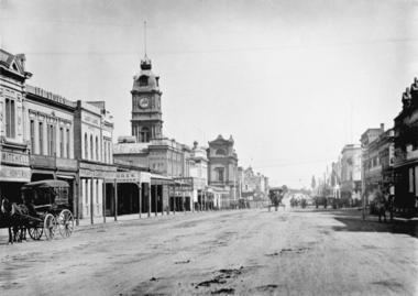
Armstrong St Nth East side
... Armstrong St Nth East side...east side... Ballarat goldfields Armstrong St Nth East side This photograph ...This photograph is from the Max Harris Collection held by the Ballaraat Mechanics' Institute. Please contact BMI for all print and usage inquiries.ballarat, armstrong st nth, east side, town hall -
 Port Melbourne Historical & Preservation Society
Photograph - Kiosk, east side Station Pier, Port Melbourne, Pat Grainger, 1988 - 1990s
... Kiosk, east side Station Pier, Port Melbourne...East side kiosk on Station Pier in original position... Street) Port Melbourne melbourne Kiosk, east side Station Pier ...East side kiosk on Station Pier in original positionpiers and wharves - station pier -
 Ringwood and District Historical Society
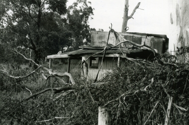
Photograph-B&W, Wantirna Road Shack next to Dandenong Creek on East Side of Wantirna Road (near the bridge), 6/07/1989
... Wantirna Road Shack next to Dandenong Creek on East Side of...Wantirna Road Shack next to Dandenong Creek on East Side...A shack next to Dandenong Creek / East side of Wantirna... Shack next to Dandenong Creek on East Side of Wantirna Road ...Wantirna Road Shack next to Dandenong Creek on East Side of Wantirna Road (near the bridge). Has been there many years - maybe 40 and it is still there (18.9.1989). (Note this is NOT part of Hill's dairy but was in the same series of photographs so kept together).A shack next to Dandenong Creek / East side of Wantirna Road / Has been there many years - maybe 40 / It is still there (18.9.89) -
 Port Melbourne Historical & Preservation Society
Photograph - Post Office Place, east side, Port Melbourne, Janet and Allen Walsh, 1973
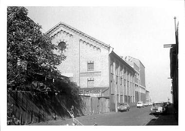
... Post Office Place, east side, Port Melbourne, ...Post Office Place, east side. Shows rear of Harpers... Identified and dated on back in ink Post Office Place, east side ...Shot in 1973 with particular interest in architecturePost Office Place, east side. Shows rear of Harpers Oriental Mill on left. 1973 Identified and dated on back in inkbuilt environment - commercial, built environment - domestic, built environment - industrial, post office place, harpers oriental mill -
 Port Melbourne Historical & Preservation Society
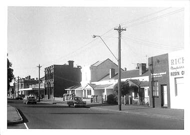
Photograph - 324-364 Bay Street, east side from Behan & Speed to Spring Street corner, Port Melbourne, Janet and Allen Walsh, 1973
... 324-364 Bay Street, east side from Behan & Speed to Spring..., east side from Bridge St...324-364 Bay Street, east side from Behan & Speed to Spring ...Shot in 1973 with particular interest in architectureSet of 31 photographs taken in June and July 1973 Bay st, east side from Bridge StIdentified and dated on back in inkbuilt environment - commercial, built environment - domestic, built environment - industrial, janet walsh, allen walsh, bay street, bridge street -
 Warrnambool and District Historical Society Inc.
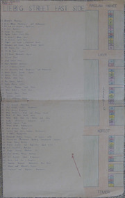
Document - Assignment: Liebig Street –East side, Circa 1951
... Assignment: Liebig Street –East side ...Provides a comprehensive list of businesses on the east... Assignment: Liebig Street –East side Document A3 fawn coloured paper ...Provides a comprehensive list of businesses on the east side of Warrnambool’s main street in the mid 20th century. An example of school work at the time as well as contributing to local historical knowledge.A3 fawn coloured paper with numbered list of businesses handwritten in blue down left hand side and corresponding numbers positioned on coloured diagram down right hand side. Area covered is from Raglan Parade to Timor Street.Beris Henderson Form 1 Bwarrnambool, liebig street, koroit street, lava street, raglan parade, timor street -
 Ringwood and District Historical Society
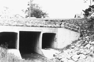
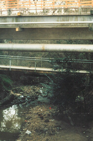
Photograph, Warrandyte Rd. culvert upstream (East) side. Ringwood 1987
... Warrandyte Rd. culvert upstream (East) side. Ringwood 1987.... culvert upstream (East) side."... upstream (East) side. Ringwood 1987 Written on back of photograph ...Written on back of photograph, "13.4.87. Warrandyte Rd. culvert upstream (East) side." -
 Ringwood and District Historical Society
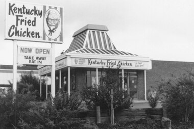
Photograph, Kentucky Fried Chicken, Whitehorse Rd, East side, Ringwood. Probably 1982
... Kentucky Fried Chicken, Whitehorse Rd, East side, Ringwood... Rd, East side."..., Whitehorse Rd, East side, Ringwood. Probably 1982 Undated, but others ...Undated, but others in the SS036 series are 1982.Catalogue card reads, "Kentucky Fried Chicken, Whitehorse Rd, East side." -
 Whitehorse Historical Society Inc.
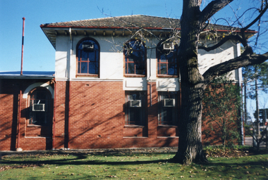
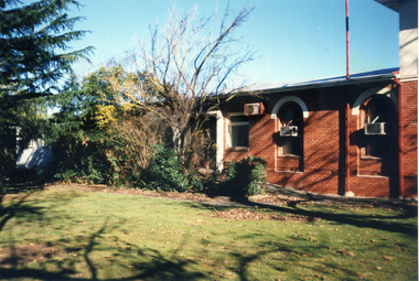
Photograph, East side of former Municipal Chambers, Nunawading, 1/06/1997 12:00:00 AM
... East side of former Municipal Chambers, Nunawading....Coloured photo of East side of former Municipal Chambers... Mitcham melbourne Photograph Photograph East side of former ...Coloured photo of East side of former Municipal Chambers of 360 Whitehorse Road, Nunawading.municipal chambers, shire of blackburn and mitcham, city of nunawading, whitehorse road, nunawading, no.360 -
 Whitehorse Historical Society Inc.
Photograph, East side of former Municipal Chambers, Nunawading, 1/06/1997 12:00:00 AM
... East side of former Municipal Chambers, Nunawading....Coloured photo of East side of former Municipal Chambers... Mitcham melbourne Photograph Photograph East side of former ...Coloured photo of East side of former Municipal Chambers at 360 Whitehorse Road, Nunawading.municipal chambers, shire of blackburn and mitcham, city of nunawading, whitehorse road, nunawading, no. 360 -
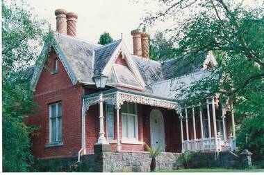
 Buninyong & District Historical Society
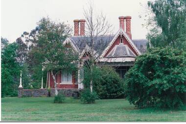
Photograph - Original Photograph, Clifton Villa (1859) Eyre St. Buninyong, front (east side), full on, 9/11/1991
... Clifton Villa (1859) Eyre St. Buninyong, front (east side..., front (east side)..... Buninyong, front (east side). Clifton Villa (1859) Eyre St ...historic building, after restorationColour photograph, Clifton Villa (1859) Eyre St. Buninyong, front (east side).buninyong, clifton villa, chimney -
 Whitehorse Historical Society Inc.
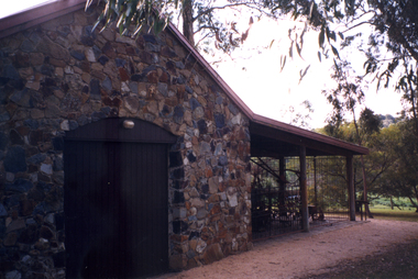
Photograph, East side of Museum
... East side of Museum...Coloured photograph of east side of Museum showing large... Mitcham melbourne Photograph Photograph East side of Museum ...Coloured photograph of east side of Museum showing large double doors and corner of implement shed.schwerkolt cottage & museum complex, nunawading & district historical society -
 Ringwood and District Historical Society
Photograph, Warrandyte Road, east side, to Aird Street and bowling green. Jan. 1975
... Warrandyte Road, east side, to Aird Street and bowling...Written on back of photograph, "Warrandyte Road, east side... on back of photograph, "Warrandyte Road, east side, to Aird Street ...Written on back of photograph, "Warrandyte Road, east side, to Aird Street and bowling green. Jan. 1975". -
 Buninyong & District Historical Society
Photograph - Original Photograph, Clifton Villa (1859) Eyre St. Buninyong, front (east side), 9/11/1991
... Clifton Villa (1859) Eyre St. Buninyong, front (east side)...., front (east side), 3/4 view..... Buninyong, front (east side), 3/4 view. Clifton Villa (1859) Eyre St ...historic building, after restorationColour photograph, Clifton Villa (1859) Eyre St. Buninyong, front (east side), 3/4 view.buninyong, clifton villa, chimney -
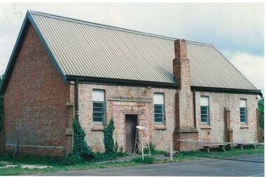 Buninyong & District Historical Society
Photograph - Original Photograph, Clive Brooks, Original Anglican Church/Common School (1857), east side, 9 Nov. 1991
... Original Anglican Church/Common School (1857), east side.... School (April 1857), east side. Part of tennis court visible... Trinity Anglican Church/Common School (April 1857), east side ...detail of historic buildingColour photo Original Holy Trinity Anglican Church/Common School (April 1857), east side. Part of tennis court visible in foreground, with net and umpire's stand.buninyong, holy trinity, tennis court, anglican, church, common school -
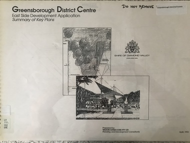 Greensborough Historical Society
Plan - Application, Wilson Sayer Core Pty Ltd, Greensborough District Centre: East side development application: summary of key plans. 1992, 1992_04
... Greensborough District Centre: East side development... Centre from 1992, with plans for the development of the East side... District Centre: East side development application: summary of key ...A summary of the plans for the Greensborough District Centre from 1992, with plans for the development of the East side of Main Street Greensborough.16 pages. Black and white line drawings and plans. Has plastic cover and wire binding. greensborough district centre, main street greensborough -
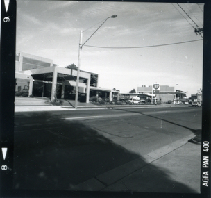 Whitehorse Historical Society Inc.
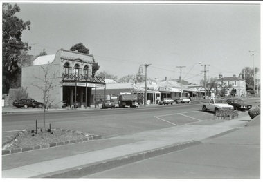
Photograph, View east side Mitcham Road, c. 1987
... View east side Mitcham Road...Black and white photograph of the east side Mitcham Road... Mitcham melbourne Photograph Photograph View east side Mitcham ...The site was the former medical rooms of Dr Stanley Cochrane and Dr Vernier ThrelkeldBlack and white photograph of the east side Mitcham Road, opposite Victoria Street, showing the office block, now (in 2004) occupied by Jobs East. c. 1987|See Historymitcham road, mitcham, victoria street, cochrane . stanley dr, threlkeld, verner w. dr. -
 Greensborough Historical Society
Booklet - Report, TTM Consulting Pty Ltd, Shire of Diamond Valley: Greensborough District Centre: "East-side" development application: traffic & parking impact report, 1992, 1992_04
... : "East-side" development application: traffic & parking impact... of the East side of Main Street Greensborough.... Valley: Greensborough District Centre: "East-side" development ...A summary of traffic ad parking impacts of the Greensborough District Centre in 1992, with plans for the development of the East side of Main Street Greensborough.14 pages text and 11 pages black and white line drawings. greensborough district centre, main street greensborough, traffic, parking -
 Buninyong & District Historical Society
Photograph - Original B/W Photograph, Clive Brooks, Warrenheip St Buninyong, east side, between Forest and Learmonth, 18/9/1993
... Warrenheip St Buninyong, east side, between Forest and...B/W photo, Warrenheip St Buninyong, east side, between..., east side, between Forest and Learmonth, B/W photo, Warrenheip ...Record of central Buninyong 1993B/W photo, Warrenheip St Buninyong, east side, between Forest and Learmonth, former Eagle Hotel at centre, Former National Bank far right, Town Hall Tower visible in background. buninyong, warrenheip st., eagle hotel, national bank -
 Ringwood and District Historical Society
Photograph, Ringwood, Mullum Mullum Creek, east side. Warrandyte Road Bridge. 1986
... Ringwood, Mullum Mullum Creek, east side. Warrandyte Road.... Ringwood, Mullum Mullum Creek, east side. Warrandyte Road Bridge".... Mullum Creek, east side. Warrandyte Road Bridge. 1986 Written ...Written on backing sheet, "Bridge, Mullum Rd. Completed May 1987." Writing on back of photograph reads, "Aug., 1986. Ringwood, Mullum Mullum Creek, east side. Warrandyte Road Bridge". -
 Ballaarat Mechanics' Institute (BMI Ballarat)
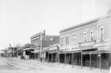
East Side Doveton St Nth
... East Side Doveton St Nth... Ballarat goldfields East Side Doveton St Nth This photograph ...This photograph is from the Max Harris Collection held by the Ballaraat Mechanics' Institute. Please contact BMI for all print and usage inquiries.ballarat, doveton -
 Tarnagulla History Archive
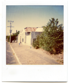
Polaroid photograph: Buildings on east side Commercial Road, Tarnagulla
... Polaroid photograph: Buildings on east side Commercial Road... on east side Commercial Road, Tarnagulla David Gordon Collection ...David Gordon Collection. -
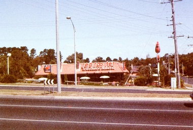 Ringwood and District Historical Society
Photograph, Red Rooster Barbecued Chicken shop at the corner of Cutts Avenue and Maroondah Highway, east side in 1985
... Avenue and Maroondah Highway, east side in 1985..., east side in 1985 Photo taken by Marion Mitchell (nee Robinson ...Photo taken by Marion Mitchell (nee Robinson) in 1985. The shop was often pranked by removing the "s" from rooster. -
 Eltham District Historical Society Inc
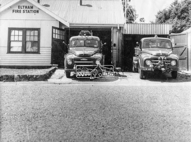
Photograph, Hugh Fisher, Eltham Fire Station, east side of Main Road, 1950s
... Eltham Fire Station, east side of Main Road, 1950s... melbourne Photograph Photograph Eltham Fire Station, east side ...The Eltham Fire Station was opened in 31 April 1935. Years later the building was removed and erected for use of 1st Research Scout Group in Research Park by the early 1970s to make way for the Eltham Village Complex which was under construction by 1971. The Research Scout Hall was destroyed by fire in 2002.Black and white photographPhoto by Hugh Fischer, c.1950seltham, fire station, main road -
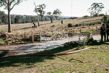 Eltham District Historical Society Inc
Slide, On the east side of Bonds Road looking west onto Martin's property, Lower Plenty, 18 July 1972, 1972
... On the east side of Bonds Road looking west onto Martin's... melbourne Slide On the east side of Bonds Road looking west onto ...Water drainage work undertaken by Eltham Shire Council in Bonds Road, Lower Plenty outside the Martin property opposite Montpelier Drive, July 1972 35 mm colour positive transparency Mount - Agfacolor Service (Blue)Bonds Road (Martin property) 12.10 pm 18.7.72bonds road, drainage works, eltham shire council, infrastructure, lower plenty, martin property, montpelier drive -
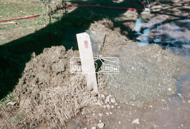
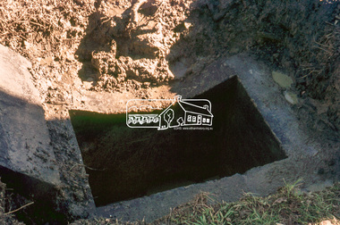 Eltham District Historical Society Inc
Slide, Pit located on the east side of Bonds Road, Lower Plenty, 18 July 1972, 1972
... Pit located on the east side of Bonds Road, Lower Plenty... melbourne Slide Pit located on the east side of Bonds Road, Lower ...Water drainage work undertaken by Eltham Shire Council in Bonds Road, Lower Plenty outside the Martin property opposite Montpelier Drive, July 1972 35 mm colour positive transparency Mount - Agfacolor Service (Blue)Bonds Road (Martin property) 12.10 pm 18.7.72bonds road, drainage works, eltham shire council, infrastructure, lower plenty, martin property, montpelier drive -
 Eltham District Historical Society Inc
Slide, Pit on east side of Bonds Road, Lower Plenty, 18 July 1972, 1972
... Pit on east side of Bonds Road, Lower Plenty, 18 July 1972... melbourne Slide Pit on east side of Bonds Road, Lower Plenty, 18 ...Water drainage work undertaken by Eltham Shire Council in Bonds Road, Lower Plenty outside the Martin property opposite Montpelier Drive, July 1972 Note rubbish excavated from pit.35 mm colour positive transparency Mount - Agfacolor Service (Blue)Bonds Road (Martin property) 12.10 pm 18.7.72bonds road, drainage works, eltham shire council, infrastructure, lower plenty, martin property, montpelier drive -
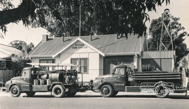
 Eltham District Historical Society Inc
Photograph, George W. Bell, Eltham Fire Station, east side of Main Road, c.Jan 1964
... Eltham Fire Station, east side of Main Road... melbourne Photograph Photograph Eltham Fire Station, east side ...The photograph was taken (and donated) by George W. Bell during the period of fire, c.1963-c.1964. The actual fire station was built c.1930 and was in use till c.1964 when a new fire station was built on the opposite side of Main Road. The building, originally situated just south of Arthur Street, on Main Road was ultimately relocated in 1970 to Research Park for use by the 1st Research Scout group. The site is now part of the current Coles supermarket and Eltham Village complex. The Fire Trucks are an Austin STU (small town unit) on the left and an Austin urban pumper on the right. This photo forms part of a collection of photographs gathered by the Shire of Eltham for their centenary project book,"Pioneers and Painters: 100 years of the Shire of Eltham" by Alan Marshall (1971). The collection of over 500 images is held in partnership between Eltham District Historical Society and Yarra Plenty Regional Library (Eltham Library) and is now formally known as 'The Shire of Eltham Pioneers Photograph Collection.' It is significant in being the first community sourced collection representing the places and people of the Shire's first one hundred years.Digital imageaustin stu fire truck, austin urban pumper, eltham, eltham fire brigade, fire station, fire truck, george w. bell, motor vehicles, shire of eltham pioneers photograph collection -
 Eltham District Historical Society Inc
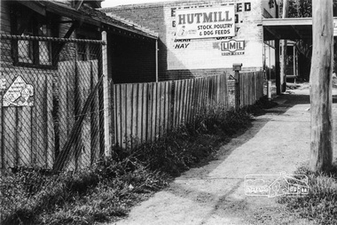
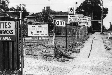
Photograph, Looking south along the east side of Main Road towards York Street, Eltham, February 1968, Feb 1968
... Looking south along the east side of Main Road towards York... melbourne Photograph Looking south along the east side of Main Road ...Shows Eltham Stock and Poultry Feed Store. Site of current Le Pine Funeral Home In February 1968 an unknown person took a series of photos from the Eltham Hotel at Pitt Street heading north along Main Road through the shopping centre to just north of Elsa Court covering the length of the section of Main Road which was duplicated shortly thereafter. Shows the condition and environment of the streesscape of Main Road, Eltham immediately prior to the duplication between Pitt Street and Elsa Court through the shopping centre. Also shows a number of shops and businesses that operated at that time.Black and white photographduplication, eltham, main road, briquettes, fuel merchant, le pine funeral home, york street, a.r warren, eltham feed store -
 Eltham District Historical Society Inc
Photograph, Looking south along the east side of Main Road towards York Street, Eltham, February 1968, Feb 1968
... Looking south along the east side of Main Road towards York... melbourne Photograph Looking south along the east side of Main Road ...Shows Eltham Stock and Poultry Feed Store. Site of current Le Pine Funeral Home In February 1968 an unknown person took a series of photos from the Eltham Hotel at Pitt Street heading north along Main Road through the shopping centre to just north of Elsa Court covering the length of the section of Main Road which was duplicated shortly thereafter. Shows the condition and environment of the streesscape of Main Road, Eltham immediately prior to the duplication between Pitt Street and Elsa Court through the shopping centre. Also shows a number of shops and businesses that operated at that time.Black and white photographduplication, eltham, main road, briquettes, fuel merchant, le pine funeral home, york street, a.r warren, eltham feed store